In a recent blog post, “GIS Tools and Applications to Give Land Brokers a Competitive Advantage,” we discussed the unique challenges of a land broker in comparison to a more typical residential real estate broker. We also honed in on the challenges of bringing interested buyers to the listed property in order to explore the property line and all the unique benefits the large acreage property has to offer. But how do land brokers reach out to potential buyers? Where do land brokers find individuals that would be interested in either buying a large acreage property or selling their own large tract of land? When determining which land brokerage company to use for buying or selling a large acreage tract – either for hunting, recreation, harvesting timber or farming, most experts advise buyers and sellers to use the land broker with a large database, or a large marketing reach. But how does a land broker or land brokerage firm build a database of current large acreage land owners?
Land Brokers Use GIS Tools Like the ReportAll Parcel Data
Starting a database of large acreage land owners can be difficult and expensive. Using ReportAll’s online national parcel database is an inexpensive method of gathering owner information and mailing addresses of large acreage land owners across the nation.
Buy Parcel Data for a County, a State or Specific Property Parcels
ReportAll USA provides parcel data such as property lines and property attributes, including acreage, land use class, property owner name, owner mailing address and more. When a land broker uses the ReportAll Online advanced search, for only $2.99/day, the user can search a national database to see how many large acreage property owners they could add to a database to mail postcards or other marketing efforts.
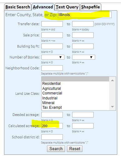
In the example illustrated here, we enter the state of Illinois in the County, State or Zip field, enter 200 in the
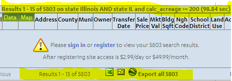
calculated acreage field and select “submit.” At no cost one can see that such a search will reveal 5,803 parcels. We can register and sign-in for just $2.99 to receive full details on

our screen regarding these 5,803 properties in Illinois with 200 acres or more.
Once signed in, we can then buy each record to be downloaded, with full property attributes, in Excel, Shapefile and KML format.
The pricing of the records is amortized so that in this case, the last 4,293 records are purchased for as little as 0.03 (just three cents).
Mailing List Database of Large Acreage Property Owners in Under an Hour
Through the use of GIS technology, ReportAll’s data collection expertise and the technology our team has pioneered, a land broker can build an audience, or a database of over 5,000 large acreage property owners in Illinois within minutes, in this one example. ReportAll regularly updates parcel data across the nation with 24/7 availability to over 148.5 million parcels in almost 3,000 counties, or 97.9% coverage of the United States. To shop counties, or see when the parcel data was last updated, click through to the state in question from our Data Store page. Or use the parcel search feature now to learn how many properties fit your criteria before you decide to buy a day pass or download parcel data.