When Hurricane Katrina hit in 2005 it was devastating. The damage was widespread, and in many cases the storm had taken out all visible means of property identification. There were no houses, no street signs, and in some areas, no streets.
Recently, as Hurricane Florence tore through North Carolina, South Carolina and Virginia we saw parts of that area submerged after the storm dumped 36 inches of rain, knocking down power to homes and businesses and removing street signs, landmarks and methods of visually identifying a property throughout the area.
This left emergency personnel and anyone else who needed to know the location of a property completely in the dark. In a natural disaster, how do first responders find their way when all signs, and the roads themselves, are gone? After the initial danger has passed, finding those in need and assessing critical infrastructure damage is critical to restoring safety to a community struck by any disaster. Searching areas for people that need shelter, are stranded on rooftops or require special assistance to relocate could be near impossible when an address becomes virtually meaningless without our typical geographic network.
Emergency Response Teams Benefit from GIS Technology
Technology has progressed since Hurricane Katrina, in 2005, delivering new tools and options for emergency responders, insurance claims adjusters, and others in need of a property’s location or ownership information while on a site. With the advancement of GIS technology coordinating response teams and locating specific addresses is no longer dependent on street signs, roads and landmarks. (Read: Disaster Planning, Management and Recovery with GIS Data.)
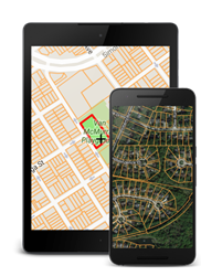
LandGlide: GIS Tool Helps Identify Properties After a Natural Disaster
One of these options is LandGlide. Combining the GPS capabilities in mobile devices with our nationwide parcel database, LandGlide is able to display parcel property lines, property address, property owner information and other parcel data while at the location where all visible landmarks have been rendered non-identifiable. Using LandGlide will help expedite the process for any government agency or business where knowing an exact property’s boundary or ownership information is required. In the weeks after a disaster, LandGlide is a crucial tool for insurance claims adjusters, construction professionals and local government. Try a 7-day free trial of LandGlide today by visiting either the Apple App Store or Google Play.
LandGlide, our Online Property Lines Map App
For more information about our online property lines map app with property owner information read related posts: